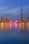
Stock photo: Skyline of Toronto Blue Sky CN Tower Toronto Islands Ferry City of Toronto Ontario
Stock photo of Toronto's skyline against a clear, cloudy, and blue sky with CN Tower and Toronto Islands Ferry in the City of Toronto, Ontario, Canada.

Stock Photos from the collection "Illuminated Stock Photos"

 = click to scroll forwards/backwards
Skyline of Toronto Blue Sky CN Tower Toronto Islands Ferry City of Toronto Ontario
This stock photo includes the city of Toronto's skyline as seen from water level far out on Lake Ontario, with the CN Tower and the Toronto Islands Ferry also in this scene in the City of Toronto, Ontario, Canada.
The city is intersected by two rivers and numerous tributaries: the Humber River in the west end and the Don River east of downtown at opposite ends of the Toronto Harbour. The harbour was naturally created by sediment build-up from lake currents that created the Toronto Islands.
The many creeks and rivers cutting from north toward the lake created large tracts of densely forested ravines, and provide ideal sites for parks and recreational trails. However, the ravines also interfere with the city's grid plan, and this results in major thoroughfares such as Finch Avenue, Leslie Street, Lawrence Avenue, and St. Clair Avenue terminating on one side of ravines and continuing on the other side.
Other thoroughfares such as the Prince Edward Viaduct are required to span above the ravines.
Related stock photo search terms for:
Skyline of Toronto Blue Sky CN Tower Toronto Islands Ferry City of Toronto Ontario
- Architectural Stock Photos (387)
- Architecture Stock Photos (418)
- Blue Sky Stock Photos (223)
- Building Stock Photos (385)
- Canada Stock Photos (650)
- Central Canada Stock Photos (198)
- Cities Stock Photos (84)
- City Stock Photos (292)
- Cityscape Stock Photos (31)
- Clouds Stock Photos (65)
- CN Tower Stock Photos (12)
- Commercial Building Stock Photos (81)
- Dusk Stock Photos (59)
- Ecology Stock Photos (337)
- Ecosystem Stock Photos (336)
- Edifice Stock Photos (293)
- Edifices Stock Photos (293)
- Environment Stock Photos (337)
- Environmentalism Stock Photos (337)
- Ferry Stock Photos (4)
- Great Lakes Stock Photos (109)
- High Rise Stock Photos (40)
- Lake Ontario Stock Photos (54)
- Lake Stock Photos (70)
- Nightfall Stock Photos (59)
- North America Stock Photos (613)
- Ontario Stock Photos (194)
- Scenery Stock Photos (287)
- Sky Stock Photos (274)
- Skyline Stock Photos (34)
- Structures Stock Photos (330)
- Toronto Stock Photos (54)
- Water Stock Photos (195)
- Weather Stock Photos (164)
Related pictures with keyword "Toronto"
Stock photo of Toronto's skyline against a clear, cloudy, and blue sky with CN Tower and Toronto Islands Ferry in the City of Toronto, Ontario, Canada.

 Request Image License
 Create a lightbox
 Add to favorites


